Hong Kong’s preparedness and resilient infrastructure cut economic losses from typhoons
For the urban coastal city of Hong Kong, typhoons are a regular occurrence from May to October. Consequently, Hong Kong’s infrastructure is designed to cope with the strong winds, floods, and storm surges they bring. Recently, however, the territory experienced two powerful storms in consecutive years. In 2017, Super Typhoon Hato struck the region, and in the following year, the city witnessed Super Typhoon Mangkhut, the strongest typhoon since 1983. But Hong Kong suffered lower economic losses from both storms when compared with the neighboring Guangdong region and the city of Macau, thanks partly to its well-coordinated response and resilient infrastructure.
“Mangkhut had a bigger impact on Hong Kong, and is one of the strongest storms I have seen,” says Ms. Frances Lai, who was brought up in the city. Ms. Lai, who works in a kindergarten, says that the roof of the school library was damaged due to fallen trees.
Hong Kong, a Special Administrative Region of China, ranks the highest in Asia and third in the world as the city with the highest risk of disasters, according to the 2015 Sustainable Cities Index of 50 cities worldwide by consultancy firm ARCADIS. Located east of the Pearl River estuary at the coast of Southern China, the densely populated city of around 7.5 million, is hit by an average of six tropical cyclones a year, according to data from the past 50 years ending 2010.
A 2020 study quantified the losses due to both Hato and Mangkhut in the Guangdong-Hong Kong-Macau Greater Bay Area. Guangdong, the most populous province of China, consists of nine cities including Guangzhou and Shenzhen. Direct economic loss was estimated using data reports by various government departments, public utilities, organizations, and statistics on insurance claims.
The total economic loss suffered by Hong Kong from both storms, 0.22 per cent of the city’s 2017 Gross Domestic Product (GDP), was lower than that of Macau and Guangdong, which bore losses of 2.41 per cent and 0.40 per cent of their 2017 GDP, respectively. According to the authors, the relatively lower loss may be partly attributed to the close coordination of the Hong Kong Observatory (HKO) with other governmental engineering departments to establish and regularly review the engineering standards to protect the city from disasters.
When Hong Kong was hit by Hato in 2017—which rapidly intensified just before it made landfall—low-lying areas were flooded with seawater due to fierce storm surges, which coincided with high astronomical tides. Two regions suffered substantial damages. The Hong Kong Special Administrative Region (HKSAR) Government’s Civil Engineering and Development Department (CEDD) undertook infrastructure enhancement works in these areas to strengthen their resilience. The works were completed before the arrival of the next typhoon season.
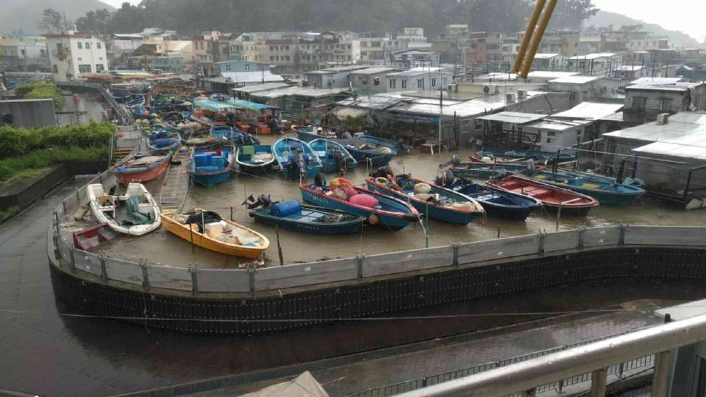
Tai O is a low-lying fishing village situated on west Lantau Island, which lies west of Hong Kong Island. The CEDD constructed rubble-mound structures at the seashore of a street near Tai O Heritage Hotel to enhance protection against high waves during typhoons. The Home Affairs Department erected concrete walls on certain sections of the coastal pavement in the area.
The HKO, in collaboration with other departments, has an early alert mechanism before a typhoon approaches. “When the water level is forecast to reach the corresponding alert level for storm surge vulnerable areas under the influence of tropical cyclones, HKO will issue SMS alert messages to relevant government departments” and “leaders of the concerned community,” explains Dr. Tsz-cheung Lee, senior scientific officer at the HKO.
Upon receiving this SMS, the Drainage Services Department (DSD), which is responsible for monitoring flooding in the city, deploys contractors to install demountable flood barriers at various locations as an added layer of protection. Both the concrete walls and the demountable barriers comprised a ‘protection zone’ at the central district of Tai O.
The ‘protection zone’ reduced damages to property during Mangkhut, says a spokesperson from the DSD. “There was generally no flooding inside the protection zone in Tai O during Mangkhut, while the flood depth outside the zone could reach 0.7m or even higher, depending on the ground level.”
Another area, Lei Yue Mun, situated in the narrowest part of the harbor in the east, consists of several fishing villages. To reduce the influx of seawater from overtopping waves, the CEDD constructed rock-armored bunds and gabion walls at various locations along the seafront.
A year later, Super Typhoon Mangkhut pounded the city, prompting the observatory to hoist its highest tropical cyclone warning signal, the Hurricane Signal, for 10 hours on 16 September 2018—the second-longest duration of a Hurricane Signal since World War II.
“The wind strength over Hong Kong during the passage of Mangkhut was generally stronger than that of the tropical storms necessitating the issuance of No. 10 Signals in the last three decades,” Dr. Chun-wing Choy, a scientific officer at the Hong Kong Observatory, points out.
Maximum 60-minute mean wind speeds recorded at North Point on Hong Kong Island and Cheung Chau Island (southwest of Hong Kong) were 110 km/hr and 157 km/hr, respectively. Gusts in most parts of the territory exceeded 150 km/hr. Severe storm surge raised the water level in many areas of Hong Kong by over two meters and five out of six tide stations in the territory registered record-breaking storm surges.
“I was sitting in my armchair and felt myself swaying,” says Ms. Debbie Mannas, who lives on the 50th floor of a high-rise building in Lantau Island near the city’s airport. “I thought I had vertigo. So, I sat up straight, tightened my body to stop me from swaying, but it didn’t work.”
Mannas was shocked to realize that it was, in fact, the building that was swaying. “My son felt it next and then my husband,” she says, adding “we went downstairs because we started feeling nauseous.” They saw many other people who had also come down to escape the swaying.
Private buildings in Hong Kong are designed to withstand winds and gusts triggered by a Hurricane Signal, says a spokesperson from the Buildings Department (BD). The Code of Practice on Wind Effects (Wind Code) published by the BD provides guidelines on building elements under typhoon wind actions. In the latest 2019 edition of the Wind Code, new parameters were introduced to enhance the capability of buildings in resisting extreme wind forces. These include the effects of uneven wind pressures and acceptable levels of occupant comfort due to building vibration, explains the BD spokesperson.
“After the completion of improvement works along part of the seafront at Lei Yue Mun and Tai O areas, we have not observed damage to seashore protection structures after the attack of Super Typhoon Mangkhut in 2018,” noted a spokesperson from the Hong Kong Special Administrative Region (HKSAR) Government’s Civil Engineering and Development Department (CEDD).
But, Typhoon Mangkhut was ferocious, and more coastal areas in the territory were flooded with seawater. As a result, similar infrastructure enhancements such as wave walls were erected in other vulnerable areas. In fact, the direct economic loss to Hong Kong due to Mangkhut was 3.8 times more than the loss due to Hato in 2017 owing to its “extensive circulation, ferocious winds and fast movement, as well as its special wind structure,” according to Dr. Choy and his colleagues from the HKO.
Post-Mangkhut, a tide gauge was installed at Lei Yue Mun by the DSD, which allows real-time monitoring of the sea level. “This enables deployment of resources in a timely manner and thus could help reduce casualties and damages to the local households,” a DSD spokesperson says. “In addition, the tide gauge allows long-term monitoring of the sea levels, which would help the government review long-term trends and data in the future.”
Similarly, Hong Kong’s CEDD introduced advanced surveying technologies—a Multibeam Echo Sounder and a Laser Scanner System—to improve the inspection of underwater marine facilities. “The Multibeam Echo Sounder works by transmitting sound waves and receiving echoes underwater to measure the structural forms of underwater marine facilities such as seawalls and breakwaters through computer analysis, whereas the Laser Scanner System measures the conditions of marine facilities at above water level,” explains a CEDD spokesperson.
In the past, diving teams had to be employed to carry out inspections, who were subject to challenging conditions such as low underwater visibility, says the CEDD spokesperson. “The new integrated system can effectively shorten the inspection time, quickly locate the damage locations, and boost repair work efficiency.” These technologies “facilitate our routine maintenance to prolong the service of marine structures,” the spokesperson says, adding that “a more effective maintenance inspection will, in turn, save the repair cost of our marine structures in the long run.”
Population growth in low-lying areas combined with urban development in reclaimed lands could increase the risk of damage from storms. Moreover, as the climate warms, tropical storms are expected to increase in intensity. In 2020, a study reported that under the influence of future global warming, storm surges arising from tropical storms in Hong Kong could increase by 8.5 per cent in 2075–2099. With the added effect of rising sea levels, storm tides (the sum of astronomical tide and storm surge) could be almost one meter higher near Hong Kong waters.
Jinghua Wang, an Assistant Professor at The Hong Kong Polytechnic University, says Hong Kong should plan for powerful storm surges caused by the onslaught of stronger typhoons in the South China Sea. “City planners should consider the extreme conditions more comprehensively in the planning and design stage of urban and coastal infrastructures,” Dr. Wang says, adding that “efficient and reliable forecast technologies should be developed and employed to predict their occurrences.”
For future developments in coastal areas, “policymakers should pay great attention to mean sea level rise, which will affect many low-lying areas in Hong Kong in the near future,” Dr. Wang emphasized. His newly published study simulates the impact of a concurrent storm-tide-tsunami event if Hong Kong is inundated by a storm surge from a typhoon with high astronomical tides coinciding with a potential tsunami generated from an earthquake in the Manila subduction zone.
In the Port Works Design Manual, which recommends standards and methods for the design of marine works, “the combined effect of storm surges during storm attacks and astronomical tide levels have been included in calculating the extreme sea levels,” explains the CEDD spokesperson.
The CEDD updated the Port Works Design Manual early in 2018 to incorporate the rise in mean sea level due to climate change up to the end of the century. The Buildings Department says they will periodically review the technical requirements of the Wind Code to address the effects of extreme winds due to climate change.
Mangkhut’s severity provided a glimpse of the kind of destruction Hong Kong could face from severe storm surges in low-lying coastal areas. “The CEDD is carrying out a study to update the extreme sea level, taking into account the tide records obtained during the Mangkhut attack,” says a spokesperson from the department. The lessons learned from Hato and Mangkhut are a warning to the city to be equipped for similar storms in the future amidst the backdrop of climate change.