Earthquakes 101

Deep beneath our feet, the Earth is far from still. Our planet’s shell is divided into massive tectonic plates that are constantly shifting. However, these plates don't always move smoothly; they often get locked together by friction. When the pressure between these plates reaches a breaking point, an earthquake occurs. This sudden snap releases powerful seismic waves that ripple through the crust. Most of this activity is concentrated in the Pacific Ring of Fire and the Alpide Belt, the two most active seismic zones on earth.
Source: Adapted from the Global Earthquake Model’s Global Seismic Hazard (Johnson et al. 2023) and Risk (Silva et al. 2023)
"Our understanding of the physics of earthquakes is at an all-time high. We know how to make buildings safer. Yet the risk of losses is rising. Trend is not destiny; it can be reversed."

Kamal Kishore
Special Representative of the UN Secretary-General for Disaster Risk Reduction
Measuring earthquakes
Source: USGS
The size of an earthquake is measured using a magnitude scale. One of the most common systems is the Moment Magnitude (Mw) scale, which shows how much energy the earthquake releases. Magnitude scales are logarithmic, meaning that even a small increase represents a large jump in strength. For example, a magnitude 5.3 earthquake shakes the ground 10 times more than a 4.3, and releases about 32 times more energy.
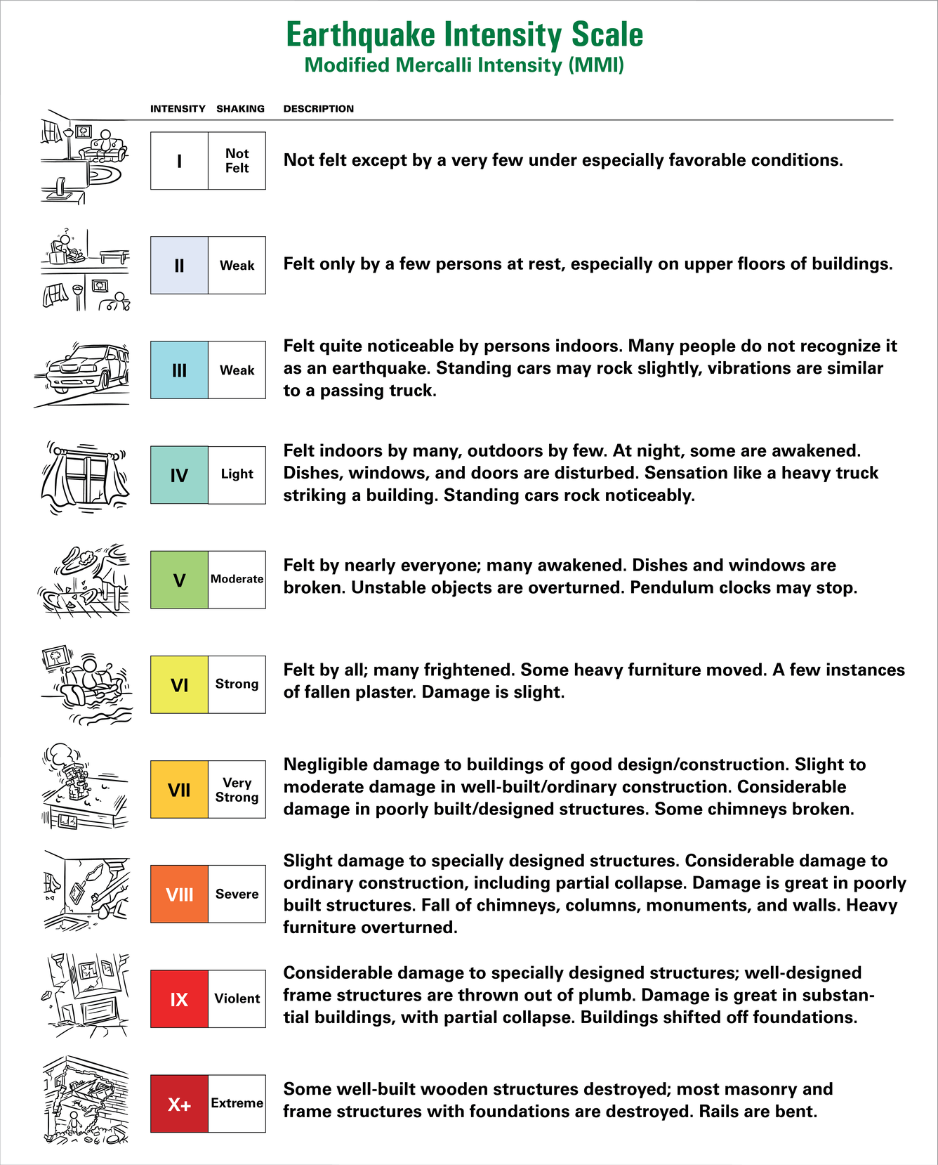
Earthquakes are also described by intensity, which measures how strongly the shaking is felt in a particular location. Intensity depends on factors such as distance from the fault, the depth of the earthquake, soil conditions, and the strength of buildings. To describe these effects, scientists use intensity scales, such as the Modified Mercalli Intensity (MMI) scale, the MSK scale, or the European Macroseismic Scale (EMS‑98). These scales are based on observations of how people felt the shaking, how objects moved, and the level of visible damage to buildings and the environment.
The MMI scale ranges from I (Not felt) to XII (Total damage). Structural damage usually begins around MMI VI, although this can vary depending on building quality. Later studies also showed that some damage described in early intensity reports was caused not only by shaking but also by ground failure, such as landslides or soil collapse (Adapted from Hazard Information Profiles (HIPs)).
Magnitude vs. intensity: What is the difference?
Earthquakes are measured in two main ways: magnitude and intensity, and each tells us something different about the event.
Magnitude describes the energy released at the earthquake’s source.
Intensity describes the effects on the ground in a specific place.
This means one earthquake has one magnitude, but it can produce many different intensities depending on where you are.
General guide to earthquake impacts
- 7.0 and above: Intense shaking with the potential for widespread, severe damage.
- 6.0–6.9: Can cause serious damage near the epicenter.
- Below 6.0: Usually causes limited damage but can still be dangerous for weak or vulnerable buildings.
Forecasting vs predicting
Some success has been achieved in developing early warning systems, which detect earthquakes close to the source or fault rupture, and trigger warnings to more distant locations, providing seconds to minutes of advance warning (Gasparini et al., 2007).
To design earthquake-resistant cities, scientists and engineers must measure more than just the size of a quake. They use high-precision seismic sensors and accelerometers at monitoring stations to capture exactly how the earth moves.
Key parameters of ground motion
Seismologists track three critical metrics to understand the physical force of an earthquake:
- Peak Ground Acceleration (PGA)
- Peak Ground Velocity (PGV)
- Spectral Acceleration (SA)
These scientific measurements aren't just numbers—they are the foundation of modern earthquake engineering. By analysing PGA, PGV, and SA, experts can develop stricter building codes for high-risk zones and simulate how new skyscrapers will behave during a "Big One."
Intensive and extensive risk
Extensive risk is used to describe the risk associated with low-severity, high-frequency events, mainly but not exclusively associated with highly localized hazards. Intensive risk is used to describe the risk associated to high-severity, mid to low-frequency events, mainly associated with major hazards.
Earthquakes are an example of intensive risk – these are risks associated with high-severity, mid to low-frequency disasters.
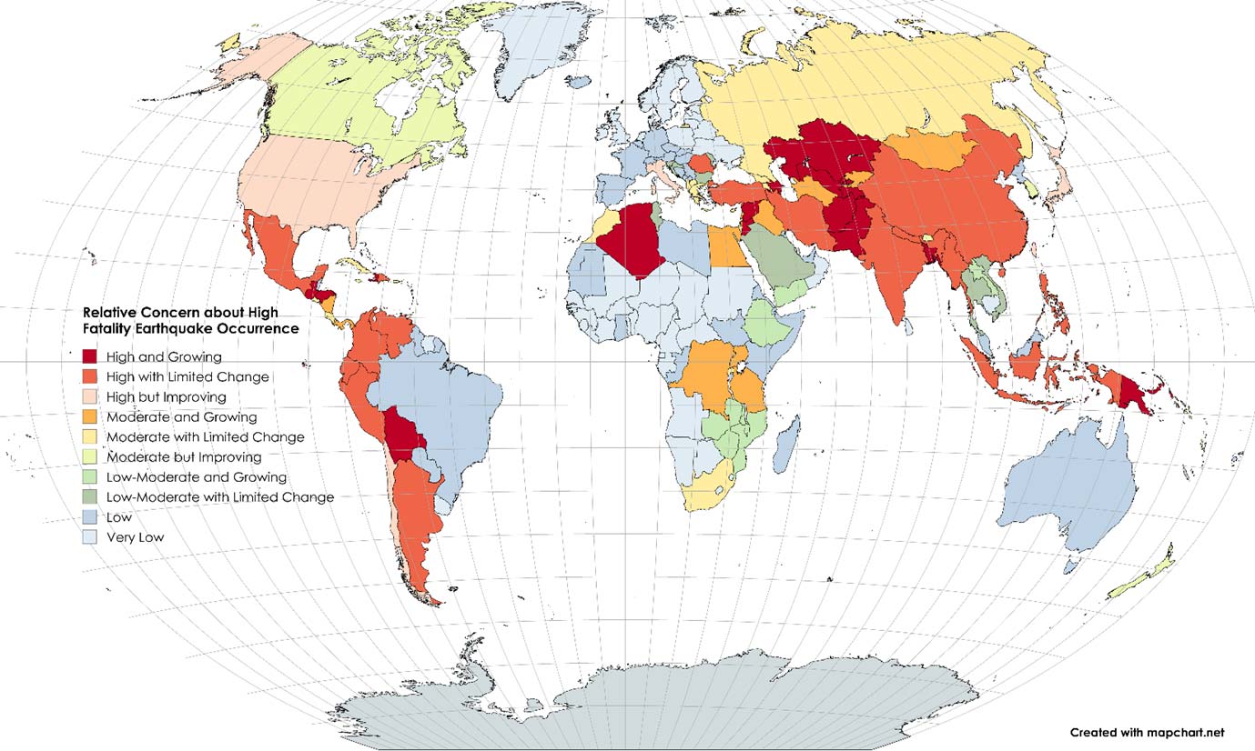
Earthquakes with 1,000 or more fatalities globally, 1900-2023
To understand the impact of historical earthquakes, we rely on decades of seismic data. Each major event provides crucial information on how different terrains and structures respond to ground motion. Modern monitoring goes beyond recording the shock, it identifies the specific frequencies that cause buildings to fail.


Source: GEO-HAZARDS international using the International Disaster Database (EM-DAT)(CRED, 2024), with affected people estimated as deaths plus injuries if not provided in EM-DAT
Snapshot: GAR 2025 Hazards: Earthquakes
Earthquake is a term used to describe both sudden slip on a fault, and the resulting ground shaking and radiated seismic energy caused by the slip, or by volcanic or magmatic activity, or other sudden stress changes in the Earth (USGS).
Earthquakes account for over a quarter (25.6%) of global economic disaster losses.
Learning from past disasters

Learn from past disasters on the PreventionWeb knowledge base. These collections explore the lessons learned from past disasters, what were the risk drivers, impacts and efforts towards building back better.