
Extra-tropical Cyclone
An extra-tropical cyclone is a low-pressure system, which develops in latitudes outside the tropics (WMO, 1992).
Primary reference(s)
WMO, 1992. International Meteorological Vocabulary, WMO-No. 182. 2nd Edition. World Meteorological Organization (WMO). Accessed 16 May 2025.
Annotations
Additional scientific description
An extra-tropical cyclone is a storm system that primarily gets its energy from the horizontal temperature contrasts that exist in the atmosphere. Extra-tropical cyclones (also known as mid-latitude or baroclinic storms) are low-pressure systems with associated cold fronts, warm fronts, and occluded fronts. In contrast, tropical cyclones typically have little to no temperature differences across the storm at the Earth's surface and their winds are derived from the release of energy due to cloud/rain formation from the warm, moist air of the tropics (NASA, 2020).
Notes for clarification: Differences between an extra-tropical cyclone and a tropical cyclone:
- An extra-tropical cyclone is a low-pressure system that primarily gets its energy from the temperature difference in the horizontal direction across the cyclone (known as temperature gradient in meteorology). Structurally, tropical cyclones have their strongest winds near the Earth's surface, while extra-tropical cyclones have their strongest winds near the tropopause - about 8 miles (12 km) up. These differences are due to the tropical cyclone being 'warm-core' in the troposphere (below the tropopause) and the extra-tropical cyclone being 'warm-core' in the stratosphere (above the tropopause) and 'cold-core' in the troposphere. 'Warm-core' refers to being relatively warmer than the environment at the same pressure surface ('pressure surfaces' are simply another way to measure height or altitude).
- A tropical cyclone will often transform into an extra-tropical cyclone as it recurves poleward and to the east. Occasionally, an extra-tropical cyclone will lose its frontal features, develop convection near the centre of the storm and transform into a full-fledged tropical cyclone. Such a process is most common in the North Atlantic and Northwest Pacific basins. The transformation of a tropical cyclone into an extra-tropical cyclone (and vice versa) is currently one of the most challenging forecasting problems (NOAA, 2004; Hong Kong Observatory, 2019).
Extra-tropical cyclones are large rotating weather systems that occur in the extra-tropics (generally more than 30° latitude away from the equator). They consist of an approximately circular region of low surface pressure, of a radius of 100-2000 km, accompanied by cold and warm fronts. They typically develop in regions of strong horizontal temperature gradients, which are commonly denoted on a weather chart as a cold or quasi-stationary front. In turn, such fronts often connect to a pre-existing decaying extra-tropical cyclone, which itself is situated some way downstream (typically to the north-east) (CCPO, no date).
At the same time, high up in the atmosphere (around 10 km altitude), a jet stream is typically found relatively close by. In fact, the intensity of an extra-tropical cyclone is closely related to the strength of this jet stream. The strongest extra-tropical cyclones occur in the winter months when the jet stream is at its strongest. Periods when the jet stream is unusually strong can lead to two or more strong cyclones occurring within days of each other. The total lifecycle of an extra-tropical cyclone from birth (genesis) through to development and on to decay (lysis) can occasionally be more than 10 days, although somewhere in the range of 2 to 5 days is more typical (Frame et al., 2017).
Metrics and numeric limits
Not available.
Key relevant UN convention / multilateral treaty
Sendai Framework for Disaster Risk Reduction 2015-2030.
Drivers
No Available Information
Impacts
The major hazards associated with extra-tropical cyclones are high winds and precipitation (rain and snow). Precipitation occurs primarily along fronts and, on average, is not particularly intense relative to that delivered by tropical cyclones and convective storms (Frame et al., 2017).
Multi-hazard context
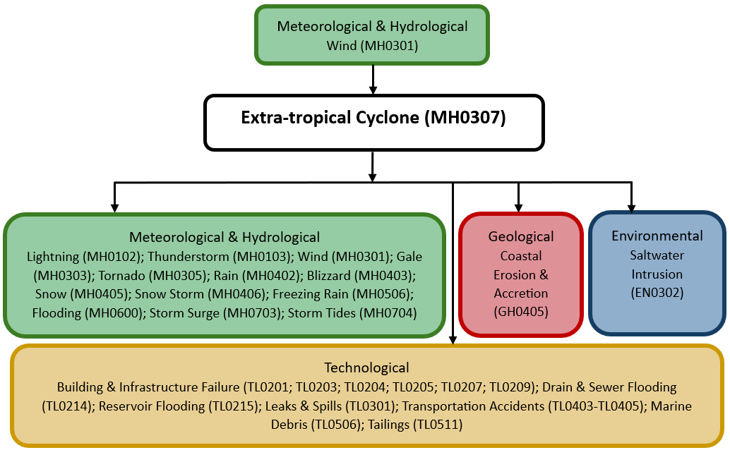
The figure below summarises common interactions between extra-tropical cyclones and other hazards. This information should be used with caution and not be solely relied upon in Disaster Risk Management, particularly as some interactions may not have been included. Note that hazardous events occurring together or locally in space or time may not necessarily cause, amplify, or be otherwise related to each other. Specific examples of multi-hazard context can be found in the ‘Hazard drivers’ and ‘Impacts’ sections above.
Multi-hazard diagram
Risk Management
No Information Available.
Monitoring
The section above and the table below offer an overview of monitoring extra-tropical cyclones. This information can be used for forecasting within a national early warning system (EWS). Since EWS capacities and processes differ across countries, the most current and specific information regarding EWS should be obtained from the appropriate national or regional agency/authority responsible for disaster management.
| Which institution(s) produce(s) Disaster Risk Data/Information? |
|
| How is the Hazard Observed/Monitored/Forecast? | Extra-tropical cyclones are monitored using technologies such as satellites, radar, and weather balloons to track wind speeds, air pressure, and storm movement. Meteorologists analyse temperature contrasts, wind patterns, and ocean conditions to predict storm development and intensity. Advanced computer models simulate storm paths, helping forecasters issue early alerts and warnings. These alerts and warnings assist communities, emergency responders, and industries to prepare for hazards such as heavy rain, snow, strong winds, and flooding. |
References
Center for Coastal Physical Oceanography (CCPO), no date. Horizontal Structure of Atmosphere. Chapter 2.. Accessed 16 May 2025
Frame, T., G. Harrison, T. Hewson and N. Roberts, 2017. Meteorological risk: extra-tropical cyclones, tropical cyclones and convective storms. In: Science for Disaster Risk Management, pp. 246-256. Accessed 16 May 2025.
Hong Kong Observatory, 2019. Extra-tropical cyclone vs Tropical Cyclone. Accessed 16 May 2025.
National Aeronautics and Space Administration (NASA), 2020. Paulette-Atlantic Ocean. Accessed 16 May 2025.
National Oceanic and Atmospheric Administration (NOAA), 2004. What is an extra-tropical cyclone? Atlantic Oceanographic & Meteorological Laboratory. Accessed 16 May 2025.