Gale (Strong Gale)
A gale is wind with a speed of between 34 and 40 knots (62–74 km/h, 32–38 mph). Also known as Beaufort scale wind force 8 (WMO, 1992).
Primary reference(s)
WMO, 1992. International Meteorological Vocabulary, WMO-No. 182. 2nd Edition. World Meteorological Organization (WMO). Accessed 16 May 2025.
Annotations
Additional scientific description
The numerical limits of a gale are defined by the Beaufort Scale, which is an empirical measure that relates wind speed to observed conditions at sea or on land (Royal Meteorological Society, 2018). Its full name is the Beaufort wind force scale.
Metrics and numeric limits
A gale is wind with a speed of between 34 and 40 knots (62–74 km/h, 32–38 mph). Also known as Beaufort scale wind force 8 (WMO, 1992).
Key relevant UN convention / multilateral treaty
Sendai Framework for Disaster Risk Reduction 2015-2030.
Drivers
No Information Available
Impacts
Human health can be severely affected by windstorms. Direct effects occur during the impact phase of a storm, causing death and injury due to the force of the wind. Becoming airborne, being struck by flying debris or falling trees and road traffic accidents are the main dangers. Indirect effects, occurring during the pre- and post-impact phases of the storm, include falls, lacerations and puncture wounds, and occur when preparing for, or cleaning up after a storm. Power outages are a key issue and can lead to electrocution, fires, burns and carbon monoxide poisoning (CH0302) from gasoline- powered electrical generators. In addition, worsening of chronic illnesses due to lack of access to medical care or medication can occur. Other health impacts include infections and insect bites (Goldman et al., 2014).
Multi-hazard context
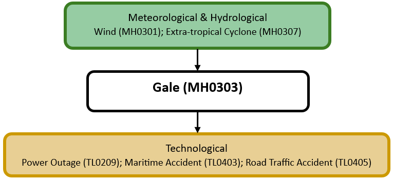
The figure below summarises common interactions between gales and other hazards. This information should be used with caution and not be solely relied upon in Disaster Risk Management, particularly as some interactions may not have been included. Note that hazardous events occurring together or locally in space or time may not necessarily cause, amplify, or be otherwise related to each other. Specific examples of multi-hazard context can be found in the ‘Hazard drivers’ and ‘Impacts’ sections above.
Multi-hazard diagram
Risk Management
Many countries have National Alerting Parameters for Gale, including the Philippines (PAGASA, no date), China (China Meteorological Administration, 2012), the Republic of Korea (Korea Meteorological Administration, 2019) and the United States (NOAA, 2019).
Monitoring
The section above and the table below offer an overview of monitoring gales. This information can be used for forecasting within a national early warning system (EWS). Since EWS capacities and processes differ across countries, the most current and specific information regarding EWS should be obtained from the appropriate national or regional agency/authority responsible for disaster management.
| Which institution(s) produce(s) Disaster Risk Data/Information? |
|
| How is the Hazard Observed/Monitored/Forecast? | Gales are monitored using ground-based wind sensors, weather observations, radar, and satellites to track wind speeds and pressure changes. Meteorologists analyse atmospheric pressure gradients and storm movement to predict gale formation. Advanced weather models forecast wind patterns, helping forecasters issue early warnings. These alerts assist mariners, aviation authorities, and communities in preparing for strong winds, rough seas, and potential infrastructure damage. |
References
China Meteorological Administration, 2012. Gale. Accessed 16 May 2025.
Goldman, A., B. Eggen, B. Golding and V. Murray, 2014. The health impacts of windstorms: a systematic literature review. Public Health, 128:3-28.
Korea Meteorological Administration, 2019. Criteria for advisory/warning information. Accessed 16 May 2025.
NOAA, 2019. Coastal Warning Display Signals. National Weather Service, National Oceanic and Atmospheric Administration (NOAA). Accessed 16 May 2025.
PAGASA, no date. Gale Warning. Accessed 16 May 2025.
Royal Meteorological Society, 2018. The Beaufort Scale: How is wind speed measured?. Accessed 16 May 2025.
WMO, 1992. International Meteorological Vocabulary, WMO-No. 182. 2nd Edition. World Meteorological Organization (WMO). Accessed 16 May 2025.