Thunderstorm
A thunderstorm is defined as one or more sudden electrical discharges, manifested by a flash of light (lightning) and a sharp or rumbling sound (thunder) (WMO, no date).
Primary reference(s)
WMO, 2017. International Cloud Atlas: Thunderstorm. World Meteorological Organization (WMO). Accessed 15 May 2025.
Annotations
Additional scientific description
hunderstorms are associated with cumulonimbus clouds (WMO, 2017) and are most often accompanied by precipitation that, when it reaches the ground, is in the form of a shower of rain, snow, snow pellets, small hail, or hail. Thunderstorms can cause tornadoes, strong winds, and flash flooding (Habitat for Humanity, 2021).
Metrics and numeric limits
Example types of thunderstorms (NOAA, no date a,b; Australian Government, no date):
| Single-cell | Single-cell thunderstorms are small, brief, weak storms that grow and die within an hour or so. They are typically driven by heating on a summer afternoon. Single-cell storms may produce brief heavy rain and lightning. |
| Multi-cell | A multi-cell storm is a thunderstorm in which new updrafts form along the leading edge of rain-cooled air (the gust front). Individual cells usually last 30 to 60 minutes, while the system as a whole may last for many hours. Multicell storms may produce hail, strong winds, brief tornadoes, and/or flooding. |
| Squall line | A squall line is a group of storms arranged in a line, often accompanied by ‘squalls’ of high wind and heavy rain. Squall lines tend to pass quickly and are less prone to produce tornadoes than are supercells. They can be hundreds of miles long but are typically only 10 or 20 miles wide. |
| Supercell | A supercell is a long-lived (greater than 1 hour) and highly organised storm feeding off an updraft (a rising current of air) that is tilted and rotating. This rotating updraft – as large as 16 kilometres (10 miles) in diameter and up to ~15,000 meters (50,000 feet) tall – can be present as much as 20 to 60 minutes before a tornado forms. Scientists call this rotation a mesocyclone when it is detected by Doppler radar. The tornado is a very small extension of this larger rotation. Most large and violent tornadoes come from supercells. |
| Mesoscale convective system | A mesoscale convective system (MCS) is a collection of thunderstorms that act as a system. An MCS can spread across large areas and last more than 12 hours. On radar, one of these might appear as a solid line, a broken line, or a cluster of cells. |
| Mesoscale convective complex | A mesoscale convective complex (MCC) – a particular type of MCS – is a large, circular, long-lived cluster of showers and thunderstorms identified by satellite. It often emerges out of other storm types during the late-night and early-morning hours. |
| Mesoscale convective vortex | A mesoscale convective vortex (MCV) is a low-pressure centre within an MCS that pulls winds into a circling pattern, or vortex. With a core only 30 to 60 miles wide and 1 to 3 miles deep, an MCV is often overlooked in standard weather analyses. But an MCV can take on a life of its own, persisting for up to 12 hours after its parent MCS has dissipated. This orphaned MCV will sometimes then become the seed of the next thunderstorm outbreak. An MCV that moves into tropical waters, such as the Gulf of Mexico, can serve as the nucleus for a tropical storm or hurricane. |
| Derecho | A derecho (pronounced similar to ‘deh-REY-cho’ in English) is a widespread, long-lived wind storm that is associated with a band of rapidly moving showers or thunderstorms. Although a derecho can produce destruction similar to that of tornadoes, the damage typically is directed in one direction along a relatively straight swath. As a result, the term ‘straight-line wind damage’ is sometimes used to describe derecho damage. By definition, if the wind damage swath extends more than 400 kilometres (~250 miles) and includes wind gusts of at least 93 km/h (58 mph) or more along most of its length, then the event may be classified as a derecho. |
| Virga | Thunderstorms can be considered dry if they do not produce any rain at the surface. However, for the fire weather community, a ‘dry thunderstorm’ may be used to describe a storm producing very little rainfall, such that it is not effective in checking fire spread after lightning ignition. The second scenario is more common, although there are rare instances when thunderstorms produce no sensible rainfall. In the purest sense, ‘dry’ thunderstorms produce rain just below the cloud base but due to a very dry atmosphere below the cloud base, the rain evaporates at some point between the cloud base and the ground. Meteorologically speaking, this is called a virga. |
Key relevant UN convention / multilateral treaty
Sendai Framework for Disaster Risk Reduction 2015-2030
Drivers
Thunderstorms are meteorological events characterized by the presence of lightning and thunder, often accompanied by heavy rainfall, strong winds, hail, and occasionally tornadoes. They develop when three primary conditions converge: moisture in the lower atmosphere, atmospheric instability (where warm air is overlain by cooler air aloft), and a lifting mechanism such as a cold front or sea breeze that forces the warm, moist air to rise. As this air ascends, it cools and condenses, forming cumulonimbus clouds and initiating the convective processes that lead to thunderstorms. (National Weather Service [NWS], 2024)
Impacts
The impacts of thunderstorms are diverse and can be severe. Lightning strikes are a significant hazard, responsible for numerous fires and fatalities annually. Heavy rainfall can lead to flash flooding, which causes more deaths each year than hurricanes, tornadoes, or lightning. Strong winds associated with thunderstorms can damage structures, uproot trees, and pose risks to aviation. Hailstones, sometimes reaching sizes comparable to softballs, can cause substantial damage to vehicles, windows, and crops. Additionally, thunderstorms can spawn tornadoes, leading to further destruction. (National Severe Storms Laboratory [NSSL], 2024)
Thunderstorm outflow concentrates airborne allergens, such as pollen, near ground level, increasing the risk of exposure for predisposed individuals and epidemic thunderstorm asthma events contribute to an increased severity of asthmatic symptoms within sensitized populations. Although infrequent, they are a global phenomenon, with 26 known events reported worldwide and may be responsible for a large number of asthma exacerbations resulting in hospitalizations and occasionally deaths Incidents have been documented in 1994 in London UK Venables et al 1997), in 2013 in Iran, in 2016 in Saudi Arabia, and in 2016 Melbourne, Australia epidemic (Price et al 2021).
Thunderstorms can also pose direct threats to human safety. Lightning strikes alone cause numerous fatalities and injuries each year. According to the National Weather Service (NWS), an average of 20-30 people die annually in the United States due to lightning strikes, with many more suffering severe injuries (NOAA, 2023). Flash flooding, often triggered by heavy rainfall in thunderstorms, is another major hazard, leading to drowning deaths and property damage.
Severe thunderstorms can disrupt power supplies, damage buildings, and affect transportation networks. Lightning can ignite wildfires and damage electrical grids, resulting in power outages that may last for days (Alpay et al., 2020). Strong winds and hail can damage or destroy crops, negatively impacting agricultural production (Elahi et al., 2022).
Thunderstorms also pose significant risks to the transportation sector, particularly aviation, leading to delays, turbulence, low-level wind-shear and even aircraft damage (U.S. Department of Transportation, 2013). Road transportation is also affected, as strong gusts of wind, flooding and toppled trees can create dangerous driving conditions (MeteoSwiss, no date).
Multi-hazard context
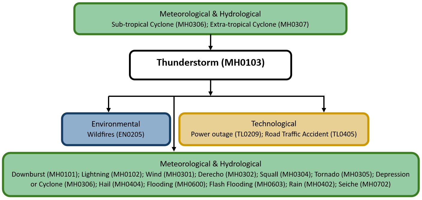
The figure below summarises common interactions between thunderstorms and other hazards. This information should be used with caution and not be solely relied upon in Disaster Risk Management, particularly as some interactions may not have been included. Note that hazardous events occurring together or locally in space or time may not necessarily cause, amplify, or be otherwise related to each other. Specific examples of multi-hazard context can be found in the ‘Hazard drivers’ and ‘Impacts’ sections above.
Multi-hazard diagram
Risk Management
Effective risk management for thunderstorms involves several strategies. Implementing early warning systems, such as monitoring weather forecasts and staying alert to severe weather advisories, is crucial. Strengthening infrastructure to withstand strong winds and ensuring proper drainage systems can mitigate damage from wind and flooding. Public education campaigns are essential to inform individuals about safety measures, such as seeking shelter during storms and avoiding contact with electrical appliances and plumbing, which can conduct electricity from lightning strikes. Developing and regularly updating emergency response plans ensure coordinated actions among emergency services and community organizations during and after storm events. (National Oceanic and Atmospheric Administration [NOAA], 2024)
A comprehensive approach toward management and prevention of ETSA includes environmental strategies, with forecasting and early warning to reduce exposure; and public health strategies, which include taking proper precautions to remain indoors, taking preventive inhaled steroids, and having ready access to inhalers (Price et al 2021).
Monitoring
The section above and the table below offer an overview of monitoring thunderstorms. This information can be used for forecasting within a national early warning system (EWS). Since EWS capacities and processes differ across countries, the most current and specific information regarding EWS should be obtained from the appropriate national or regional agency/authority responsible for disaster management.
| Which institution(s) produce(s) Disaster Risk Data/Information? |
|
| How is the Hazard Observed/Monitored/Forecast? | Thunderstorms are monitored using Doppler radar, weather satellites, and ground-based sensors that track cloud formations, wind patterns, and lightning activity. Meteorologists analyse temperature, humidity, and wind shear to predict storm development and intensity. Advanced weather models and real-time data help forecast thunderstorms and their movement, allowing for early warnings to protect aviation, infrastructure, and communities from hazards like heavy rain, strong winds, lightning, and hail. |
References
Alpay, B.A., Wanik, D., Watson, P., Cerrai, D., Liang, G. and Anagnostou, E., 2020. ‘Dynamic modeling of power outages caused by thunderstorms’, Forecasting, 2(2), pp. 151–162. Accessed 15 May 2025.
Australian Government (no date). Severe thunderstorms. Bureau of Meteorology. Accessed 15 May 2025.
Elahi, E., Khalid, Z., Tauni, M.Z., Zhang, H. and Lirong, X., 2022. ‘Extreme weather events risk to crop-production and the adaptation of innovative management strategies to mitigate the risk: A retrospective survey of rural Punjab, Pakistan’, Technovation, 117, 102255. Accessed 15 May 2025.
Habitat for Humanity, 2021. Thunderstorms. Accessed 15 May 2025.
Federal Office of Meteorology and Climatology MeteoSwiss, no date. Thunderstorms. Accessed 15 May 2025.
National Oceanic and Atmospheric Administration (NOAA), 2023. Lightning safety. Accessed 15 May 2025.
National Oceanic and Atmospheric Administration (NOAA), no date a. Severe weather 101: Thunderstorm types. National Severe Storms Laboratory. Accessed 15 May 2025.
National Oceanic and Atmospheric Administration (NOAA), no date b. Types of thunderstorms: Ordinary cell. National Weather Service. Accessed 15 May 2025.
National Oceanic and Atmospheric Administration (NOAA), no date c. Watch/warning/advisory definitions. National Weather Service. Accessed 15 May 2025.
National Weather Service (NWS), 2024. Thunderstorm hazards. Accessed 15 May 2025.
National Severe Storms Laboratory (NSSL), 2024. Thunderstorm basics. Accessed: 15 May 2025.
National Oceanic and Atmospheric Administration (NOAA), 2024. Staying ahead of the storms. Accessed 15 May 2025.
Price, D., Hughes, K.M., Thien, F. and Suphioglu, C., 2021. ‘Epidemic thunderstorm asthma: Lessons learned from the storm Down-Under’, The Journal of Allergy and Clinical Immunology: In Practice, 9(4). Accessed 15 May 2025.
U.S. Department of Transportation, 2013. Advisory circular: Thunderstorms. Federal Aviation Administration. Accessed 15 May 2025.
Venables, K., Allitt, U., Collier, C., Emberlin, J., Greig, J., Hardaker, P., Highham, J., Laing-Morton, T., Maynard, R., Murray, V., Strachan, D. and Tee, R. (1997) ‘Thunderstorm-related asthma—the epidemic of 24/25 June 1994’, Clinical and Experimental Allergy, 27(7), pp. 725–736.
World Meteorological Organization (WMO), 2017. Cumulonimbus (Cb) (Weilbach 1880). Accessed 15 May 2025.