Coastal Erosion and Accretion
Coastal erosion is the process of removal of material at the shoreline which leads to the loss of land as the shoreline retreats landward. Coastal accretion is the product of deposition of material at the shoreline which leads to gain of land as the coast advances seaward (Gibb, 1978).
Primary reference(s)
DCLG, 2010. Planning Policy Statement 25 Supplement: Development and Coastal Change. Department of Communities and Local Government. ISBN: 978 1 4098 2323 0
Gibb, J.G. 1978. Rates of coastal erosion and accretion in New Zealand. New Zealand Journal of Marine and Freshwater Research, 12 (4) 429-456.
Mentaschi, L., M.I. Vousdoukas, J. Pekel, E. Voukouvalas and L. Feyen, 2018. Global long-term observations of coastal erosion and accretion. Scientific Reports, 8:12876.
Schwartz, M.,2005. Encyclopaedia of Coastal Science, Springer.
Annotations
Additional scientific description
Coastal erosion and accretion hazards physically expose coastal areas to the risk of property damage, loss of life, and environmental degradation (c.f. Schwartz, 2005). The coastal zone, extending between fully terrestrial environments and marine environments unaffected by waves, is a dynamic setting which is subject to constantly changing energy inputs. Land-based processes deliver sediment to coastal environments where they are mobilised and transported by nearshore and wider marine processes. Rates of coastal erosion reflect the consequences of environmental change (human modifications and climate change) superimposed on natural variability in the underlying process-driven rates of erosion (Mentaschi et al., 2018). The landward movement of the coast through erosion can be as high as several metres per year but may be mitigated by sediment accretion. Understanding patterns of sediment migration is fundamental to modelling coastal change. Coastal change processes are wide-ranging; both marine and land processes present hazards to coastal environments including infrastructure, business, people, and ecosystem services in the coastal zone (Wong et al., 2014; Mentaschi et al., 2018).
Marine processes are largely governed by tides, tidal range, tidal surges, coastal flooding, waves, tsunami, long-shore transport and a range of types of current. Landsliding processes include falls, topples, slides and flows reflecting the local geological and groundwater conditions. Groynes, jetties, seawalls, breakwaters, rip-rap, other anthropogenic structures and practices have a major influence on coastal change. For example, Mentaschi et al. (2018) found that dams are among the most prominent contributors to erosion because they retain sediment that would otherwise naturally supply the coastal zone with beach sediment.
Sediment and global sea-level rise impact on coastal erosion and accretion. Sediment loading can exacerbate regional subsidence, thereby increasing the relative sea-level rise. In coastal areas where accelerated glacial wasting has been reported, glacio-isostatic rebound results in a relative rise in ground level, as exemplified in the wasting of the Laurentide Ice Sheet (Simon et al., 2016)
Subduction zone earthquakes can cause persistent (decades-long) or permanent reconfigurations of a coastline and associated patterns of erosion and accretion. Uplift during an earthquake can lead to dramatic decreases in the depth and utility of harbours. Subsidence during a Magnitude 8-9 subduction zone earthquake caused coastal communities, highways, and other infrastructure to sink below sea level, and the establishment of a new shoreline inland by several tens to hundreds of metres (Plafker, 1965).
Metrics and numeric limits
Mentaschi et al. (2018) used satellite data to evaluate global coastal morphodynamics along horizontal 30m grids over the period 1984 to 2015. They established a land loss of 28,000 km2; gained land of 14,000 km2; an increase in the active zone (essentially the intertidal zone together with areas frequently inundated by fresh, brackish or marine waters) of 25,000 km2, and a loss in the active zone of 11,500 km2. The region with the highest change per unit area over the time period was the Caspian Sea with an average cross-shore erosion of 600 m, followed by southern Asia, Pacific Asia, South America, eastern Africa and western Australia with an average cross-shore erosion of 50 m.
Key relevant UN convention / multilateral treaty
The United Nations Convention on the Law of the Sea (UNCLOS) provides a comprehensive framework for the regulation of all ocean space, including the protection and preservation of the marine environment, which encompasses coastal erosion and accretion processes.
Drivers
Extreme weather events associated with high intensity storm surges and flooding as well as tsunami and waves and currents which influence the extent and rate of erosion or accumulation of coastal landforms. Extreme rainfall events contribute to soil saturation and associated shear strength reduction associated with landsliding. Anthropogenic factors impact most significantly on sediment supply primarily through sediment retention.
Impacts
Coastal morphology, which is directly impacted by coastal erosion and accretion, heavily impacts the distribution and scale of other coastal hazards, including coastal flooding (MH0601), estuarine flooding (MH0602), storm surges (MH0703), storm tides (MH0704), tropical cyclones (MH0309), sub-tropical cyclones (MH0308), tsunami (MH0705), loss of mangroves (EN0207), sand mining (EN0405), sea-level rise and indirectly on hazards that have significant biological or health impacts, including harmful algal blooms (BI0603). Coasts have high population densities and significant investments in infrastructure and the built environment. Coastal development too frequently occurs with little consideration for coastal erosion or accretion. Despite the likelihood of climate change exacerbating them (IPCC, 2014), many densely populated regions of the world are being affected by these hazards.
The impacts of coastal erosion and accretion hazards are often compounded by coastal hazards with mainly biological or health impacts. These include harmful algal blooms (HABs) which occur when colonies of algae grow out of control while producing toxic or harmful effects on people, fish, shellfish, marine mammals, and birds. They commonly occur in nutrient (mainly phosphorus, nitrogen, and carbon) rich, poorly circulated waters. People often get sick by eating shellfish containing toxins produced by the algae. Airborne HAB toxins may also cause breathing problems and, in some cases, trigger asthma attacks in susceptible individuals. NOAA 2024.
Multi-hazard context
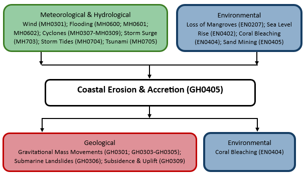
The figure below summarises common interactions between coastal erosion & accretion and other hazards. This information should be used with caution and not be solely relied upon in Disaster Risk Management, particularly as some interactions may not have been included. Note that hazardous events occurring together or locally in space or time may not necessarily cause, amplify, or be otherwise related to each other. Specific examples of multi-hazard context can be found in the ‘Hazard drivers’ and ‘Impacts’ sections above.
Multi-hazard diagram
Risk Management
Coastal change poses a threat to coastal settlements, businesses and tourism. Coastal environments host a range of infrastructure, including the landing points for telecommunications, ecosystem services and in the order of 40% of the world’s population (Mentaschi et al., 2018). Coastal erosion becomes a hazard when society does not adapt to its effects on people, the built environment and infrastructure (UNDRR, 2017). Therefore, adaptation and adaptive pathways are a key policy in managing coastal hazards. In some parts of the world a range of engineered interventions have been successful in protecting specific infrastructure and populations, but the consequences of engineered intervention need to be fully appraised to avoid unplanned consequences. Engineered solutions vary widely, and include utilization of rock armour, breakwaters, groynes, seawalls, wharfs and harbours, offshore barriers, a range of styles of revetments, beach nourishment or replenishment, mangrove protection and dredging (Climate-ADAPT, 2015). Coastal change can impact harbour water depth and damage infrastructure. In these zones, modelling to enable adaptive planning is one of the best forms of mitigation (Steven et al., 2020). It can also affect groundwater resources, such as saline intrusion (USGS, no date). Potential impacts are especially significant for atoll islands with shallow unsaturated zones. These islands are particularly susceptible to impacts on groundwater resources and populations (UNESCO, 2019).
Examples of regional and national programmes for coastal erosion and coastal change include the first pan-European shoreline-migration map, prepared by the European Marine Observation and Data Network (EMODnet, 2020) and the UK national coastal erosion risk map, prepared by the UK Environment Agency.
Monitoring
The section and the table below offer an overview of monitoring coastal erosion & accretion. This information can be used for forecasting within a national early warning system (EWS). Since EWS capacities and processes differ across countries, the most current and specific information regarding EWS should be obtained from the appropriate national or regional agency/authority responsible for disaster management.
| Which institution(s) produce(s) Disaster Risk Data/Information? | National agencies (e.g. the European Marine Observation and Data Network; UK Environmental Agency in the UK). |
| How is the Hazard Observed/Monitored/Forecast? | Extensive mapping programmes |
References
CIRIA, 1996. Beach management manual. CIRIA Report 153. ISBN 9780860174387.
Climate-ADAPT, 2015. Groynes, Breakwaters and artificial reefs. Climate- ADAPT. Accessed 28 April 2021.
EMODnet, 2020. First pan-European shoreline-migration map since 2004 European 2007-17 data. European Marine Observation and Data Network (EMODnet). Accessed 30 September 2020.
IPCC, 2014. Climate Change 2014: Impacts, Adaptation, and Vulnerability – Working Group II Report. Available at: https://www.ipcc.ch/report/ar5/wg2/ [Accessed 13 Feb. 2025].
Mentaschi, L., M.I. Vousdoukas, J. Pekel, E. Voukouvalas and L. Feyen, 2018. Global long-term observations of coastal erosion and accretion. Scientific Reports, 8:12876.
Plafker, G., 1965. Tectonic deformation associated with the 1964 Alaska earthquake. Science, 148:1675-1687.
Schwartz, M.,2005. Encyclopaedia of Coastal Science, Dordrecht: Springer.
Simon, K.M., T.S. James, J.A. Henton and A.S. Dyke, 2016. A glacial isostatic adjustment model for the central and northern Laurentide Ice Sheet based on relative sea level and GPS measurements. Geophysical Journal International, 205:1618-1636.
Steven, A.D.L., K. Appeaning Addo, G. Llewellyn, T.C. Vu, et al., 2020. Coastal Development: Resilience, Restoration and Infrastructure Requirements. World Resources Institute. Accessed 13 February 2025.
UNESCO, 2019. Small islands: meeting the challenges of freshwater resilience. Accessed 13 February 2025.
UNDRR, 2017. National Disaster Risk Assessment: Governance System, Methodologies, and Use of Results. United Nations Office for Disaster Risk Reduction (UNDRR). Accessed 13 February 2025.
USGS, no date. Saltwater intrusion. United States Geological Survey. Accessed 13 February 2025.
Wong, P.P., I.J. Losada, J.P. Gattuso, J. Hinkel et al., 2014. Coastal systems and low-lying areas. In: Climate Change 2014: Impacts, Adaptation, and Vulnerability. Part A:Global and Sectoral Aspects. Contribution of Working Group II to the Fifth Assessment Report of the Intergovernmental Panel on Climate Change. Pp. 361-409. Cambridge University Press. Accessed 13 February 2025.