Sea Level Rise
Sea-level change (sea-level rise / sea-level fall) refers to a change in the height of sea level, both globally and locally (relative sea-level change), at seasonal, annual, or longer time scales. It results from a change in ocean volume due to a change in the mass of water in the ocean (e.g. melting of glaciers and ice sheets), changes in ocean water density (e.g. expansion under warmer conditions), changes in the shape of ocean basins, changes in the Earth's gravitational and rotational fields, and local land subsidence or uplift (IPCC, 2019).
Primary reference(s)
Annotations
Additional scientific description
Global sea level measured as the distance from the centre of the Earth to the surface of the ocean is termed eustatic sea level (Rovere et al., 2016). Global mean sea-level change resulting from a change in the ocean's mass is termed barystatic. The amount of barystatic sea-level change due to the addition or removal of water mass is referred to as its sea-level equivalent (SLE). Sea-level changes caused by changes in water density are termed steric. Density changes due to temperature are called thermosteric, and those due to salinity are termed halosteric. Barystatic and steric changes exclude changes caused by ocean basin shape or redistribution of ocean mass (IPCC, 2019).
Global mean sea level rose by 0.20 m (0.15-0.25 m) between 1901 and 2018 (Fox-Kemper et al., 2021).
The rate of sea-level rise has increased since the late 1960s, averaging 2.3 mm [1.6 to 3.1 mm] yr⁻¹ from 1971-2018, increasing to 3.7 mm [3.2 to 4.2 mm] yr⁻¹ from 2006-2018 (Fox-Kemper et al., 2021).
The IPCC projects global mean sea-level rise to be between 0.44 m (0.32-0.62 m, likely range; SSP1-2.6) and 0.77 m (0.63-1.01 m, likely range; SSP5-8.5) by 2100 (medium confidence), relative to 1995-2014 (Fox-Kemper et al., 2021). Relative sea-level rise will differ regionally due to factors such as local oceanic currents or land uplift/subsidence.
Sea-level rise is expected to increase the frequency of extreme sea-level events. In many regions, a current 1-in-100-year inundation event could occur annually by 2050 (Oppenheimer et al., 2019). Flood frequency may increase exponentially, potentially doubling every five years (Taherkhani et al., 2020).
It is virtually certain that global sea level will continue rising after 2100, potentially by nearly 2 m to 7 m by 2300 (relative to 1900) under SSP5-8.5 (IPCC, 2021).
Significant uncertainties remain regarding the contributions of melting ice sheets in Greenland and Antarctica. Recent data suggest accelerating melt, raising concerns about potential tipping points (King et al., 2020; Ripple et al., 2023).
Metrics and numeric limits
Oppenheimer et al. (2019) state that in the context of sea-level rise and low-lying islands/coasts, 'sea level' refers to the time-averaged height of the sea surface, excluding short-term fluctuations such as tides and waves. They add:
- Global mean sea-level (GMSL) rise results from warming (lower water density) and added water mass from land ice or terrestrial water loss. Volume and mass changes redistribute ocean water, deform the lithosphere, and shift Earth's gravity field, creating regionally distinct sea-level patterns.
- Other processes-tectonics, mantle dynamics and glacial isostatic adjustment-also alter sea level through vertical land motion (VLM).
- Thus, relative sea-level (RSL) change refers to the change in the elevation difference between land and sea surface at a specific location (Farrell and Clark, 1976). Regional sea level refers to spatial scales of approximately 100 km, while local sea level refers to scales smaller than 10 km. In most locations globally, current annual mean rates of RSL change are typically on the order of a few mm yr⁻¹.
- Risk associated with changing sea level is also related to individual events of limited duration, superimposed on the background of gradual changes. As a result, these long-term temporal and spatial changes must be assessed alongside processes that lead to flooding and erosion events. Such processes include storm surges, waves and tides, or a combination thereof, and can result in extreme sea-level (ESL) events.
- Newly emerging understanding of these episodic and gradual aspects of sea-level change is assessed within the context of observed changes over the past century, as well as those inferred from longer geological timescales. This longer-term perspective is important for contextualising future sea-level projections and for improving process-based models of individual sea-level rise (SLR) components, particularly ice sheets. In addition, anthropogenic subsidence may significantly affect local sea levels in many areas, but this process is not included in the projected SLR values reported here unless specifically stated (Oppenheimer et al., 2019).
Key relevant UN convention / multilateral treaty
UN Climate Change Paris Agreement (2015) The Paris Agreement builds on the United Nations Framework Convention on Climate Change (UNFCCC) (UN and UNFCCC, 2011) and, for the first time, brings all nations into a common cause to undertake ambitious efforts to combat climate change and adapt to its effects, with enhanced support to assist developing countries to do so. As such, it charted a new course in the global climate effort. By February 2023, 195 out of 198 Parties had ratified the Paris Agreement (United Nations Climate Change, 2015; United Nations Treaty Collection, 2024).
UN Convention on the Law of the Sea (UNCLOS) lays down a comprehensive regime of law and order in the world’s oceans and seas, establishing rules governing all uses of the oceans and their resources. It enshrines the notion that all problems of ocean space are closely interrelated and must be addressed as a whole. UNCLOS entered into force in accordance with its Article 308 on 16 November 1994 (UNCLOS, 2018).
Drivers
Sea-level rise is driven by various factors acting on different timescales. For example, storms and tsunamis generate sea-level rise at the coast over short timescales, while global warming and glacial isostatic adjustment (the vertical movement of continents in response to changes in overlying ice mass) drive sea-level rise over longer periods.
Human activities such as groundwater extraction and urbanisation can lead to aquifer depletion, soil compaction and land subsidence (Hasan et al., 2023), further amplifying sea-level rise. Additionally, the loss of coastal ecosystems due to anthropogenic pressures (e.g. coral reefs and mangroves, which act as natural buffers against sea-level rise) can further intensify the impacts of sea-level rise in coastal areas.
Impacts
Sea-level rise causes a range of impacts in coastal areas, including changes in coastline morphology (erosion and accretion), coastal inundation and the degradation of coastal vegetation.
Sea-level rise modifies sediment transport along coasts through changing water currents, sediment sources and deposition zones. As a result, erosion and accretion may occur in different places and at varying rates. Although erosion is expected to be widespread and poses an existential threat to atoll islands, research suggests that some atolls are responding to sea-level rise by reshaping rather than shrinking (e.g. McLean & Kench, 2015; Duvat, 2019). While this may not reduce total land area, it does affect infrastructure and livelihoods in erosion-prone zones (see GH0405 on coastal erosion).
Sea-level rise also causes coastal inundation through overwash (Ford et al., 2018), resulting in damaged infrastructure, salinisation of groundwater and soil, and reduced crop yields. Many atoll islands already face water stress due to limited freshwater availability. Increased frequency of overwash-related inundation could make some islands uninhabitable by depleting their freshwater supplies (Storlazzi et al., 2018).
Sea-level rise in atoll islands may also cause inundation by elevating the fresh underground water lens (e.g. Habel et al., 2019). Although this type of inundation involves freshwater, which is less corrosive to infrastructure and less harmful to soil and crops, it is more difficult to manage, as conventional coastal protection strategies are ineffective against it.
Coastal vegetation is distributed according to salt tolerance. Rising sea levels will push vegetation inland, but where there is no room for retreat, ecosystems may be reduced or lost entirely (Oppenheimer et al., 2019).
Multi-hazard context
The figure below summarises common interactions between sea-level rise and other hazards. This information should be used with caution and should not be solely relied upon in disaster risk management, particularly as not all interactions may be included. Hazardous events occurring concurrently or in proximity may not necessarily cause, amplify, or relate to one another. Specific examples of the multi-hazard context can be found in the ‘Hazard drivers’ and ‘Impacts’ sections above.
Multi-hazard diagram
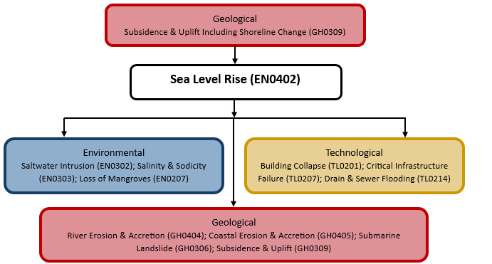
Sea-level rise is closely linked to other hazards, creating a multi-hazard environment characterised by cascading and compound events, as well as other factors that may further amplify its impacts. For example, sea-level rise exacerbates the effects of storm surges and coastal flooding, which in turn can lead to saltwater intrusion into freshwater systems, affecting coastal food production and freshwater supplies.
Compound events, such as a tropical cyclone occurring simultaneously with high tides, can contribute to coastal flooding (Tu’uholoaki et al., 2023). Conversely, such hazards can degrade built coastal defences (e.g. seawalls) and protective ecosystems (e.g. mangroves), making them more vulnerable to future sea-level rise, tropical cyclones and tides. Cascading hazards arise when sea-level rise or prolonged coastal flooding disrupts infrastructure, triggering economic, health and environmental impacts. These disruptions can also lead to conflicts over resources (e.g. fisheries) and cause population displacement.
Risk Management
Risk management for sea-level rise may be achieved through the reduction of greenhouse gas emissions. However, there is a lag of several decades between emissions reductions and a decline in sea-level rise, since the processes involved (thermal expansion due to ocean warming and ice sheet melting) respond to atmospheric warming with delay (Oppenheimer et al., 2019).
Risk management strategies for the impacts of sea-level rise at the coast are similar to those used for coastal erosion (see GH0405). These include the design and construction of engineering structures (e.g. seawalls, revetments), conservation and restoration of healthy coastal ecosystems (e.g. coral reefs and mangrove forests), development of legislation and policies on coastal zoning and building codes, and integrated coastal management with monitoring of extreme sea-level rise events (Spalding et al., 2014).
Existing frameworks—such as NOAA’s Sea Level Rise Viewer and the Netherlands Delta Programme—demonstrate how early warning systems (EWS) can combine long-term planning with immediate risk mitigation. However, significant gaps remain, particularly in underserved regions.
Risk management related to sea-level rise, especially in connection with storm surges, waves and tides—or combinations of these contributing to extreme sea-level (ESL) events—also includes the development of effective climate information and EWS. These systems enhance preparedness by delivering timely alerts and actionable information to minimise human and economic losses.
Monitoring
The section and the table below provide an overview of monitoring for sea-level rise. This information may be used for forecasting within a national early warning system (EWS). As EWS capacities and processes vary between countries, the most current and specific information should be obtained from the appropriate national or regional agency or authority responsible for disaster management.
| Which institution(s) produce(s) disaster risk data/information? | Data integration through global networks such as the Global Sea Level Observing System (GLOSS) and regional initiatives like the Pacific Islands Sea Level Monitoring Project facilitates comprehensive monitoring efforts. |
| How is the hazard observed/monitored/forecast? | Advanced monitoring technologies-such as satellites, tide gauges and ocean sensors-collect real-time data on sea-level trends and contributing factors, including ocean temperature and ice melt. |
References
Duvat, V.K.E., 2019. A global assessment of atoll island planform changes over the past decades. WIREs Climate Change, 10:e557. Accessed 19 November 2024.
Farrell, W.E., and Clark, J.A., 1976. On postglacial sea level. Geophysical Journal International, 46:647-67.
Ford, M., Merrifield, M.A., Becker, J.M., 2018. Inundation of a low-lying urban atoll island: Majuro, Marshall Islands. Natural Hazards, 91:1273-1297. Accessed 19 November 2024.
Fox-Kemper, B., Hewitt, H.T., Xiao, C., Aðalgeirsdóttir, G., Drijfhout, S.S., Edwards, T.L., Golledge, N.R., Hemer, M., Kopp, R.E., Krinner, G., Mix, A., Notz, D., Nowicki, S., Nurhati, I.S., Ruiz, L., Sallée, J.-B., Slangen, A.B.A., Yu, Y., 2021: Ocean, Cryosphere and Sea Level Change. In Climate Change 2021: The Physical Science Basis. Contribution of Working Group I to the Sixth Assessment Report of the Intergovernmental Panel on Climate Change [Masson-Delmotte, V., P. Zhai, A. Pirani, S.L. Connors, C. Péan, S. Berger, N. Caud, Y. Chen, L. Goldfarb, M.I. Gomis, M. Huang, K. Leitzell, E. Lonnoy, J.B.R. Matthews, T.K. Maycock, T. Waterfield, O. Yelekçi, R. Yu, and B. Zhou (eds.)]. Cambridge University Press, Cambridge, United Kingdom and New York, NY, USA, pp. 1211–1362, Chapter 9: Ocean, Cryosphere and Sea Level Change. Accessed 19 November 2024.
Habel, S., C.H Fletcher, K. Rotzoll, A.I. El-Kadi and D.S. Oki, 2019. Comparison of a simple hydrostatic and a data-intensive 3D numerical modeling method of simulating sea-level rise induced groundwater inundation for Honolulu, Hawai’i, USA. Environmental Research Communications, 1(4). Accessed 19 November 2024.
Hasan, M.F., Smith, R., Vajedian, S., Pommerenke, R., and Majumdar, S., 2023. Global land subsidence mapping reveals widespread loss of aquifer storage capacity. Nature Communications 14, 6180 (2023). DOI: 10.1038/s41467-023-41933-z. Accessed 19 November 2024.
IPCC, 2019. Annex I: Glossary [Weyer, N.M. (ed.)]. In: IPCC Special Report on the Ocean and Cryosphere in a Changing Climate [H.-O. Pörtner, D.C. Roberts, V. Masson-Delmotte, P. Zhai, M. Tignor, E. Poloczanska, K. Mintenbeck, A. Alegría, M. Nicolai, A. Okem, J. Petzold, B. Rama, N.M. Weyer (eds.)]. Intergovernmental Panel on Climate Change (IPCC). Accessed 20 November 2024.
King, M.D., Howat, I.M., Candela, S.G., Noh, M.J., Jeong, S., Noë,l B.P.Y., van den Broeke, M.R., Wouters, B., Negrete, A., 2020. Dynamic ice loss from the Greenland Ice Sheet driven by sustained glacier retreat. Communications Earth & Environment. 1:1. DOI: 10.1038/s43247-020-0001-2. Accessed 19 November 2024.
McLean, R., Kench, P., 2015. Destruction or persistence of coral atoll islands in the face of 20th and 21st century sea-level rise? WIREs Climate Change, 6:445-463. Accessed 19 November 2024.
Oppenheimer, M., Glavovic, B.C., Hinkel, J., van de Wal, R., Magnan, A.K., Abd-Elgawad, A., Cai, R., Cifuentes-Jara, M., DeConto, R.M., Ghosh, T., Hay, J., Isla, F., Marzeion, B., Meyssignac, B., Sebesvari, Z., 2019. Sea Level Rise and Implications for Low-Lying Islands, Coasts and Communities. In: IPCC Special Report on the Ocean and Cryosphere in a Changing Climate [H.-O. Pörtner, D.C. Roberts, V. Masson-Delmotte, P. Zhai, M. Tignor, E. Poloczanska, K. Mintenbeck, A. Alegría, M. Nicolai, A. Okem, J. Petzold, B. Rama, N.M. Weyer (eds.)]. Accessed 19 November 2024.
Ripple, W.J., Wolf, C., Gregg, J.W., Rockström, J., Newsome, T.M., Law, B.E., Marques, L., Lenton, T.M., Xu, C., Huq, S., Simons L., King, D.A., 2023. The 2023 state of the climate report: Entering uncharted territory. BioScience, 73(12), 841–850. DOI: 10.1093/biosci/biad080. Accessed 19 November 2024.
Rovere, A., Stocchi, P., Vacchi, M. 2016. Eustatic and Relative Sea Level Changes. Current Climate Change Reports 2, 221-231. Eustatic and Relative Sea Level Changes | Current Climate Change Reports. Accessed 19 November 2024.
Spalding M., McIvor, A., Tonneijck, F.H., Tol, S., van Eijk, P., 2014. Mangroves for coastal defence: guidelines for coastal managers and policy makers. Wetlands International and The Nature Conservatory. Accessed 21 November 2024.
Storlazzi, C.D., Gingerich, S.B., van Dongeren, A., Cheriton, O.M., Swarzenski, P.W., Quataert, E., Voss, C.I., Field, D.W., Annamalai, H., Piniak, G.A., McCall, R., 2018. Most atolls will be uninhabitable by the mid-21st century because of sea-level rise exacerbating wave-driven flooding. Science Advances, 4:eaap9741. Accessed 19 November 2024.
Taherkhani, M., Vitousek, S., Barnard, P.L., Frazer, N., Anderson, T.R., and Fletcher, C.H., 2020. Sea-level rise exponentially increases coastal flood frequency. Nature Scientific Reports, 10:6466. Accessed 19 November 2024.
Tu’uholoaki, M., Espejo, A., Wandres, M., Singh, A., Damlamian, H., Begg, Z., 2023. Quantifying Mechanisms Responsible for Extreme Coastal Water Levels and Flooding during Severe Tropical Cyclone Harold in Tonga, Southwest Pacific. Journal of Marine Science and Engineering, 11(6), 1217. DOI: 10.3390/jmse11061217. Accessed 19 November 2024.
UN and UNFCCC, 2011. United Nations Framework Convention on Climate Change. Kyoto Protocol, 1997. Accessed 19 November 2024.
UNCLOS, 2018. United Nations Convention on the Law of the Sea of 10 December 1982. Overview and full text. United Nations Division for Ocean Affairs and the Law of the Sea. Accessed 19 November 2024.
United Nations Climate Change, 2015. The Paris Agreement. Accessed 19 November 2024.
United Nations Treaty Collection, 2024. Paris Agreement. United Nations. Accessed 21 November 2024.