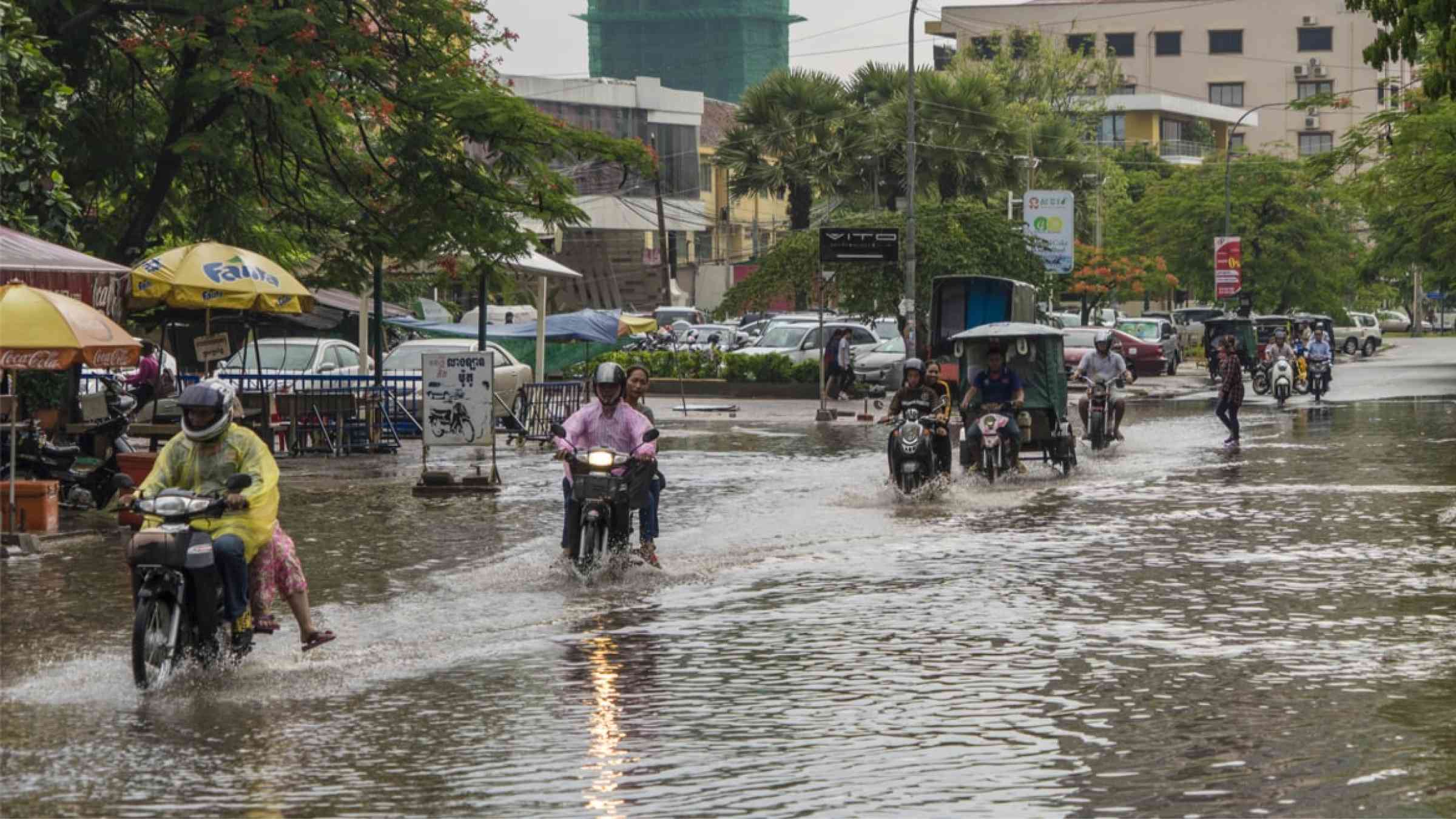
Planning resilient roads in Cambodia
Assessments of disaster impacts on sectors critical to national economies and people's livelihoods, such as infrastructure and agriculture, have repeatedly shown that sector planning needs to become more sensitive to disaster risk. Cambodia presents an example of good practice, systematically collecting, analysing, and using loss data on roads and related infrastructure, and using it for planning.
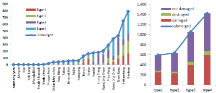
The Government of Cambodia has recognized that the transportation sector, which is vital for the country’s economic development, is regularly and severely affected by disaster impacts (N.a., 2017). Data on road damage and destruction from disasters are systematically collected, recorded and stored in the Cambodia Disaster Loss and Damage Information System (CamDi), a national database managed by the National Committee on Disaster Management (NCDM). Baseline data are collected with details on all roads and related infrastructure and recorded together with disaster loss data, allowing for cost of loss assessments, seasonal analysis and analysis by region or specific location and by road or infrastructure type (see Figures 6, 7 and 8).
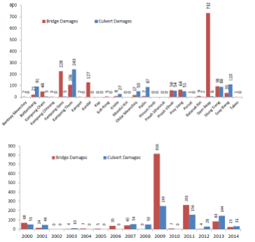
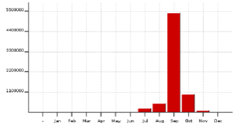
Asset-level, geographic and temporal disaggregated information on damage effects from flood events enables the Government of Cambodia to detect hotspots of vulnerability (e.g. Siem Reap), target investments and actions to hazard-proof future road infrastructure investments and tackle current exposure and susceptibility to damage through pre-emptive maintenance ahead of the rainy season and retrofits. Seasonal analysis (see Figure 9, showing peak damage in September) allows targeted anticipatory actions to minimize disruption.
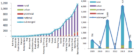
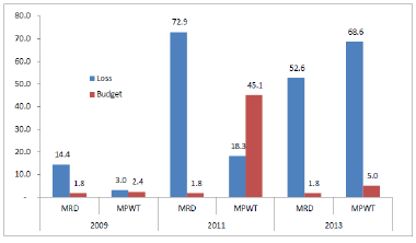
Importantly, for investment planning, losses estimates can be generated using the data for kilometres of road and infrastructure damaged, providing a solid overview of losses to the country's road sector that can then be compared with available budgets (Figure 10) and build the case for resilient investments.
Significant investments in data collection and governance are required to ensure such systematic recording and analysis of disaster losses and damages on a whole sector and to feed analytical outputs directly into policies, budgets and actions. The experience of Cambodian Ministry for Rural Development (MRD) and the Ministry for Public Works and Transport (MPWT) demonstrate coordinated efforts on pre- and post-disaster data collection routines, such as regular maintenance inspections, as well as on-site damage assessments in the event of a disaster, enable data pipelines for tracking sector granular losses and damages data.
In line with localized PDNA guidelines for the road sector developed in Cambodia to standardize assessment processes, the exact location and length of road submerged is determined for damaged and destroyed assets. In addition, information boards are set up at the affected locations with information on water depth, pothole location, boundaries of carriage ways and shoulders, limitations for use by heavy vehicles, ongoing emergency repair, etc.
The MRD and MPWT carry out on-site inspections of road damage during and after a disaster. The review of road-related disaster data in inspection reports and meeting key people in the road sector are important for the following reasons. Lessons from the Cambodia experience show that it is important for such inspections to capture systematically all “road-related disaster information such as date of flood, water depth, location, length, width, extent of damage after water recedes, description of road damage, bridges, culverts, and requirement for emergency repair.” (N.a., 2017). Without these details, losses and damages data are not as useful as they can be for planning and budgetary decisions on road rehabilitation, maintenance and upgrading, as well as risk management across the sector. As recognized by insurers and risk modellers interested in developing sector-specific catastrophe insurance products, a lack of asset disaggregated and georeferenced data limits opportunities for understanding how specific hazardous events characteristics, such as water level, flow speed or stagnation time, cause damage and dysfunction of different structures and their operational components. Other challenges are limited budgets and therefore human resources to carry out data collection on rural road damage; limited data-sharing between administrative levels and departments; and diverging data collection and reporting formats and processes, making aggregation, consolidation and analysis more challenging. However, continuing the efforts and making further investments in recording disaster damage to roads will be critical not only for this sector, but also for other key sectors, including social services (access to health centres and schools), economic growth and local market development, and urban development where resilient road infrastructure is a major component of planning. Further improvements are planned by NCDM for the maintenance and development of the Cambodia DesInventar database, known as CamDi, with a clear aim of enhancing its use by the relevant ministries. For example, the MRD can use CamDi data as evidence in preparing budget proposals; the subnational administration levels can use the data to prepare local investment plans and fundraise with national ministries; and municipal governments can use the data to inform their city-level, multi-year development plans. For these, NCDM is aiming to develop a standardized methodology for calculating the monetary value of damage and loss across all key sectors, including housing, agriculture, irrigation infrastructure and water supply systems, etc. to capitalize on the experience of the road infrastructure sector to apply disaster losses and damages data for risk-informed sector planning and risk reduction financing.
The MRD and MPWT make on-site inspection of road damages during and after a disaster. The review of road-related disaster data in inspection reports and meeting of key people in the road sector are important for the following reasons. Lessons from the Cambodia experience show that it is important for such inspections systematically capture all "road-related disaster information such as date of flood, water depth, location, length, width, extent of damage after water recedes, description of road damage, bridges, culverts, and requirement for emergency repair."[2] Without these details, losses and damages data is not as useful as it can be for planning and budgetary decisions on road rehabilitation, maintenance and upgrading, and risk management across the sector.
As recognized by insurers and risk modelers interested in development of sector-specific catastrophic insurance products, lack of asset disaggregated and georeferenced data limit the opportunities to understand how specific hazardous events characteristics, such as water elevation, flow speed or stagnation time cause damage and dysfunction of different structures and their operational components.
Remaining challenges are limited budgets and therefore human resources to carry out data collection on rural road damage; limited data sharing between administrative levels and departments; and diverging data collection and reporting formats and processes, making aggregation, consolidation, and analysis more challenging. However, continuing the efforts and making further investments in recording disaster damage to roads will be key not only for the sector, but also for other key sectors, including social services (access to health centres, schools,), economic growth and local market development, and urban development where resilient road infrastructure is a major component of planning.
Further improvements are planned by NCDM for the maintenance and development of the Cambodia Desinventar database, known as CamDi, with a clear view to enhancing its use by the relevant ministries. For example, the MRD can use CamDi data as evidence in preparing budget proposals; the subnational administration levels can use the data to prepare local investment plans and fundraise with national ministries; and municipal governments can use the data to inform their city-level multi-year development plans. For these, NCDM seeks to develop a standardised methodology for calculating the monetary value of damage and loss across all key sectors, including housing, agriculture, irrigation infrastructure and water supply systems etc to capitalize on the experience of the road infrastructure sector to apply disaster losses and damages data for risk-informed sector planning and risk reduction financing.